![](/images/other/stat-length.png)
![Trail On foot Bad Tatzmannsdorf - Wechselblick - Photo](https://media.geolcdn.com/t/1900/400/4787bbeb-6093-461d-bcb6-8fd0d5f811cb.jpeg&format=pjpeg&maxdim=2)
Wechselblick
SityTrail - itinéraires balisés pédestres
Tous les sentiers balisés d’Europe GUIDE+
![Length](/images/other/stat-length.png)
Length
6.8 km
![Max alt](https://static1.geolcdn.com/siteimages/upload/files/1508320355ic_sort_altitude_max_24dp.png)
Max alt
428 m
![Uphill gradient](https://static1.geolcdn.com/siteimages/upload/files/1508320355ic_sort_den_pos_24dp.png)
Uphill gradient
137 m
![Km-Effort](/images/other/stat-length.png)
Km-Effort
8.7 km
![Min alt](https://static1.geolcdn.com/siteimages/upload/files/1508320355ic_sort_altitude_min_24dp.png)
Min alt
345 m
![Downhill gradient](https://static1.geolcdn.com/siteimages/upload/files/1508320355ic_sort_den_neg_24dp.png)
Downhill gradient
156 m
![Boucle](https://static1.geolcdn.com/siteimages/upload/files/16400158638029165_repeat_loop_refresh_sync_direction_icon.png)
Boucle
No
Signpost
Creation date :
2022-02-16 16:23:56.345
Updated on :
2022-03-03 07:25:14.658
![On foot](https://static1.geolcdn.com/sitytour/trail-icons/100.png)
1h58
Difficulty : Easy
![Scan this QR Code to open this trail in the SityTrail application](https://capi.geolives.com/qq0zvz2zws4bq2lad0pu/sitytour/trails/3126929/qr.png?size=200)
FREE GPS app for hiking
About
Trail On foot of 6.8 km to be discovered at Burgenland, Bezirk Oberwart, Bad Tatzmannsdorf. This trail is proposed by SityTrail - itinéraires balisés pédestres.
Description
Trail created by Lauf und Walkingarena Bad Tatzmannsdorf http://www.laufarena.at/.
Symbol: Würfel auf Stange
Positioning
Country:
Austria
Region :
Burgenland
Department/Province :
Bezirk Oberwart
Municipality :
Bad Tatzmannsdorf
Location:
Unknown
Start:(Dec)
Start:(UTM)
592311 ; 5243381 (33T) N.
Comments
Trails nearby
![Trail On foot Gemeinde Mariasdorf - Grodnau - Braunriegel - Kalkgraben - Schartenäcker - Photo](https://media.geolcdn.com/t/375/260/ec4b4b2f-accf-4783-be6f-21b95bc7a733.jpeg&format=jpg&maxdim=2)
![On foot On foot](https://static1.geolcdn.com/sitytour/trail-icons/100.png)
Grodnau - Braunriegel - Kalkgraben - Schartenäcker
On foot
Easy
Gemeinde Mariasdorf,
Burgenland,
Bezirk Oberwart,
Austria
![](/images/other/stat-length.png)
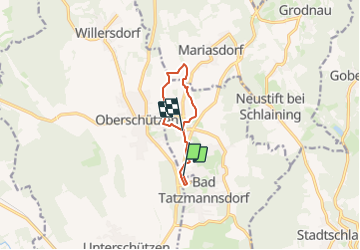
6.7 km | 9 km-effort
2h 2min
![](https://static1.geolcdn.com/siteimages/upload/files/16400158638029165_repeat_loop_refresh_sync_direction_icon.png)
Yes
![Trail On foot Gemeinde Mariasdorf - Rundwanderweg Bergwerk/Neustift - Schloss/Tauchental/Sonnleiten - Photo](https://media.geolcdn.com/t/375/260/81a9901c-285f-464b-a1c2-7917b0293c8e.jpeg&format=jpg&maxdim=2)
![On foot On foot](https://static1.geolcdn.com/sitytour/trail-icons/100.png)
Rundwanderweg Bergwerk/Neustift - Schloss/Tauchental/Sonnleiten
On foot
Easy
Gemeinde Mariasdorf,
Burgenland,
Bezirk Oberwart,
Austria
![](/images/other/stat-length.png)
7.1 km | 9.2 km-effort
2h 5min
![](https://static1.geolcdn.com/siteimages/upload/files/16400158638029165_repeat_loop_refresh_sync_direction_icon.png)
Yes
![Trail On foot Gemeinde Mariasdorf - Walking/Wanderweg W12 - Photo](https://media.geolcdn.com/t/375/260/6a410674-6df6-45f6-b5d5-1a4692b0bf00.jpeg&format=jpg&maxdim=2)
![On foot On foot](https://static1.geolcdn.com/sitytour/trail-icons/100.png)
Walking/Wanderweg W12
On foot
Easy
Gemeinde Mariasdorf,
Burgenland,
Bezirk Oberwart,
Austria
![](/images/other/stat-length.png)
11.9 km | 15.9 km-effort
3h 36min
![](https://static1.geolcdn.com/siteimages/upload/files/16400158638029165_repeat_loop_refresh_sync_direction_icon.png)
Yes
![Trail On foot Bad Tatzmannsdorf - Walking/Wanderweg W11 - Photo](https://media.geolcdn.com/t/375/260/e6c6c1eb-564e-4038-ae0f-1231eb6f5e2e.jpeg&format=jpg&maxdim=2)
![On foot On foot](https://static1.geolcdn.com/sitytour/trail-icons/100.png)
Walking/Wanderweg W11
On foot
Easy
Bad Tatzmannsdorf,
Burgenland,
Bezirk Oberwart,
Austria
![](/images/other/stat-length.png)
4.7 km | 6.5 km-effort
1h 29min
![](https://static1.geolcdn.com/siteimages/upload/files/16400158638029165_repeat_loop_refresh_sync_direction_icon.png)
No
![Trail On foot Bad Tatzmannsdorf - Lauf/Walkingweg L19 - Photo](https://media.geolcdn.com/t/375/260/c463ced7-1344-42af-a541-a8a4c701f365.jpeg&format=jpg&maxdim=2)
![On foot On foot](https://static1.geolcdn.com/sitytour/trail-icons/100.png)
Lauf/Walkingweg L19
On foot
Easy
Bad Tatzmannsdorf,
Burgenland,
Bezirk Oberwart,
Austria
![](/images/other/stat-length.png)
9 km | 12 km-effort
2h 44min
![](https://static1.geolcdn.com/siteimages/upload/files/16400158638029165_repeat_loop_refresh_sync_direction_icon.png)
Yes
![Trail On foot Bad Tatzmannsdorf - Lauf/Walkingweg L18 - Photo](https://media.geolcdn.com/t/375/260/3c472665-13a0-4831-9d82-88b376b6be68.jpeg&format=jpg&maxdim=2)
![On foot On foot](https://static1.geolcdn.com/sitytour/trail-icons/100.png)
Lauf/Walkingweg L18
On foot
Easy
Bad Tatzmannsdorf,
Burgenland,
Bezirk Oberwart,
Austria
![](/images/other/stat-length.png)
8.2 km | 10.4 km-effort
2h 22min
![](https://static1.geolcdn.com/siteimages/upload/files/16400158638029165_repeat_loop_refresh_sync_direction_icon.png)
Yes